Posts

Showing posts from February, 2025

Saut du Day Waterfall via Gorges de l'Orbe

Image
  Overview Starting Point: Les Clées (580m) End Point: Saut du Day Waterfall (650m) Alternative Ending: Le Day (800m) Distance: ~5 km (one way) Estimated Time: ~1 hour to the waterfall (longer with kids) Difficulty: Easy to moderate (some steep edges, narrow paths) Family-Friendly?: Yes, with supervision in some sections Notable Features: Scenic river views,  a mysterious  tunnel and a waterfall with a beach area Download GPS file The Start: Les Clées to the Trailhead This hike is a classic for families, offering beautiful scenery and a cool waterfall at the end. Plus, for me, it’s only 15 minutes from home—so I visit often! The Gorges de l'Orbe trail runs from Orbe to Vallorbe, but the best section lies between Les Clées and Le Saut du Day . I recommend starting in Les Clées , where you’ll also find a castle with a bar —a great spot to relax post-hike. The trailhead is located below the castle . Turn left onto a small road, passing houses and a bridge. After a...
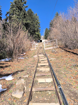
KM vertical de Fully

Image
Overview Starting Point:  Belle Usine, Fully End Point:  Top of the funicular track Elevation Gain:  1000m Distance:  1.9 km Average Slope:  52%, with sections up to 60% Record Time:  28 minutes (Kilian Jornet) Best Time to Visit:  Late summer and autumn (official race takes place once a year) Difficulty:  Extreme (requires excellent physical condition) Family-Friendly?:  No, due to steepness and technical difficulty Download GPS file The Challenge: A Legendary Vertical Climb The KM Vertical de Fully , near Martigny, is famous for being one of the steepest vertical kilometer races in Europe. These types of races challenge participants to climb 1000m of elevation in the shortest distance possible. Fully’s version follows the tracks of an old funicular, creating a direct and brutal ascent. Trail running legend Kilian Jornet holds the record at an incredible 28 minutes. Knowing I wasn’t anywhere close to Kilian’s level, I still wanted to test m...

Le sentier des innombrables, Arolla

Image
Overview Starting Point: Parking lot below the ski lifts in Arolla (1998m) End Point: Same as the starting point (circular route) Estimated Time: 2.5 - 3 hours Difficulty: Moderate (challenging without snowshoes) Total Elevation Gain: ~150m Highest Point: ~2150m Key Features: Snowshoe trail, metal artworks, ski slope crossings, forest paths Family-Friendly?: Yes, but some sections are challenging with small children Download GPS file The Beginning: Setting Off from Arolla Le Sentier des Innombrables in Arolla (1998m) is a scenic snowshoe trail featuring large metal artworks along the route. You can find all relevant information about it here . The trail begins at the parking lot just below the ski lifts in Arolla. Walk to the end of the parking area, where the road becomes snowy, and follow it for a few hundred meters until you see signs directing you to the right. That day, Gaia was not in the mood. And when Gaia isn’t in the mood, everything becomes more chall...

Dent de Vaulion – A Jura Classic with Stunning Views

Image
  Overview Starting point: Petra Félix (1,144m) Arrival: Dent de Vaulion summit (1,482m) Altitude gain: ~340m Duration: ~2 hours round trip Difficulty: Easy Best season: All year (winter possible sometimes with snowshoes) Family-friendly: Yes Sunset view: Highly recommended Download GPS file Dent de Vaulion is another one of those classic hikes that I return to every year. It’s a great hike for all seasons—you can even do it in winter with snowshoes —and its length makes it ideal for families . Starting Point: Petra Félix The hike starts just after the Col du Mollendruz pass in the Jura mountains . After passing the parking at the pass, drive for a couple of minutes until you reach a parking lot  just before the roads starts to descend. The place is called  Petra Félix (1,144m) —a name that feels like a good omen . From here, you start hiking up a gravel road for about 15 minutes . ( Note: Since I’ve done this hike so many times, I rarely take pictures anymore,...

Grande Dixence – A High-Alpine Adventure for Families

Image
  Overview Starting point: Grande Dixence Dam (2,350m, after taking the lift) Arrival: Col de Roux (2,780m) – then descent to Cabane de Prafleuri and return Altitude gain: ~430m (+100 on the return) Duration: ~3-4 hours round trip Difficulty: Moderate Best season: Late summer (to avoid snow) Family-friendly: Yes, but best for fit hiker-parents, especially if carrying a child Key highlights: The massive Grande Dixence Dam , a flat lakeside section , moonlike landscapes , and a mountain hut stop Download GPS file The Grande Dixence Dam is truly “Grande” —one of the largest gravity dams in the Alps . Visiting the dam alone is already an experience, and for thrill-seekers, there’s even a zipline that flies across its front! But our goal was a hike along the lake , taking in the high-alpine scenery. A Challenging but Rewarding Family Hike This hike is doable with a baby in a backpack (as we did), but keep in mind that you’ll reach 2,780m at the highest point and there’s a g...

Strada delle 52 Gallerie – A Hike Through History

Image
  Overview Starting point: Bocchetta Campiglia (1,216m) Arrival: Rifugio Achille Papa (1,928m) Altitude gain: ~800m Duration: ~5-6 hours round trip Difficulty: Moderate (no technical difficulties, but requires a head for heights) Best season: Late spring to early autumn Family-friendly: Yes, but some exposure to cliffs may not suit those with vertigo Key highlights: 52 wartime tunnels , breathtaking ridge views , and a historical WWI route Download GPS file The Strada delle 52 Gallerie is more than just a hike—it’s a journey through history . This extraordinary trail was built during World War I , carved into the sheer cliffs of Monte Pasubio to provide a safe supply route for Italian troops. A Feat of Wartime Engineering Monte Pasubio was of strategic importance in defending Italy from Austro-Hungarian forces . However, the main road to the peak was exposed to enemy fire , making it too dangerous to use. The only alternative? The impossibly rugged southern face of th...