KM vertical de Fully
Overview
- Starting Point: Belle Usine, Fully
- End Point: Top of the funicular track
- Elevation Gain: 1000m
- Distance: 1.9 km
- Average Slope: 52%, with sections up to 60%
- Record Time: 28 minutes (Kilian Jornet)
- Best Time to Visit: Late summer and autumn (official race takes place once a year)
- Difficulty: Extreme (requires excellent physical condition)
- Family-Friendly?: No, due to steepness and technical difficulty
The Challenge: A Legendary Vertical Climb
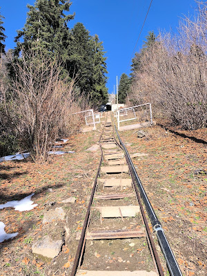
The KM Vertical de Fully, near Martigny, is famous for being one of the steepest vertical kilometer races in Europe. These types of races challenge participants to climb 1000m of elevation in the shortest distance possible. Fully’s version follows the tracks of an old funicular, creating a direct and brutal ascent. Trail running legend Kilian Jornet holds the record at an incredible 28 minutes.
Knowing I wasn’t anywhere close to Kilian’s level, I still wanted to test myself on this iconic course. It had been on my bucket list for a while, and my first encounter with the trail happened purely by chance—I arrived on race day! Since the event happens only once a year, I had no idea I had timed my visit so perfectly. Seeing hundreds of runners pushing themselves up the near-vertical incline made me even more motivated to come back and attempt it myself.
Attempt 1: Race Day Observations
Since I wasn’t signed up for the race, I couldn’t join the competitors on the main path. I attempted to walk alongside it, but the terrain was too steep, so I settled for watching. Seeing that not everyone was ascending with the grace of a mountain goat reassured me that my own attempt, while slow, would still be worth it.
Attempt 2: My Solo Ascent
A few weeks later, I returned alone, determined to make it to the top. The trail begins at Belle Usine, starting with an already steep but manageable climb through vineyards. After passing under a bridge, the gradient increases sharply. Fortunately, the old funicular tracks create makeshift steps, providing some stability—without them, the climb would be almost impossible.
The First 100 Meters: A Warm-Up?
At the first marker, indicating 100m of elevation gain, I was already sweating profusely. Even walking at a fast pace rather than running, my legs were burning. The vineyards slowly gave way to steeper terrain, and I reached a bridge so steep that walking upright became a challenge.
300m Mark: Reality Check
At around 300m of elevation, I glanced at my watch. Kilian Jornet had already reached the top by this point. That realization was both humbling and mind-blowing. He truly is a machine.
400m: Entering the Gallery
At 400m, the trail enters a steep tunnel-like gallery. The gravel surface inside made it even harder to gain traction. How anyone manages to run here remains a mystery to me.
600m: The One-Hour Mark
By the time I hit 600m of elevation, I had been climbing for an hour and fatigue was setting in. Luckily, a short section of “normal” steepness provided a brief respite—though it lasted only about 50 meters before the relentless gradient resumed.
700m: The End in Sight but Far Away
At around 700m, the small white house marking the finish came into view. It seemed deceptively close, but the final stretch was slow and grueling.
Two hikers had been following me for a while, and although this wasn’t a competition, I refused to let them pass so close to the end. That little psychological boost helped me push through the final section.
Final 50 Meters: A Last Brutal Push
The last stretch required crossing another bridge and a second gallery before the final climb to the finish. The arrival point features an information panel with a clear warning: do not descend via the same route—and with good reason. Descending such a steep incline would be extremely dangerous.
The Descent: A More Manageable Path
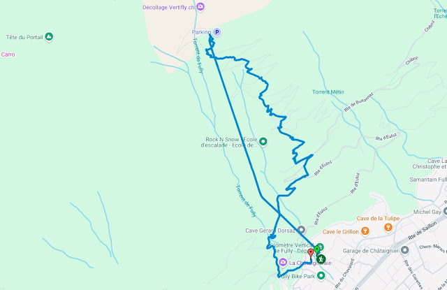
The way down follows a separate trail, still steep but considerably safer. From the top:
- Take a left from the arrival point, passing just below the white house.
- Follow the path leading to Planuit, a small village with a scenic terrace—an ideal spot to rest and grab a snack.
- Above Planuit, a narrow path reconnects to the main uphill track, in a wider section where spectators usually gather during race day.
- From Planuit, the descent continues through a forested section to the village of Euloz.
- A paved road then leads almost all the way back down to Fully.
- A final shortcut through the vineyards brings you to the first bridge, after which the path rejoins the main road behind the parking lot.
For one last thrill, I decided to descend the vineyard stairs directly. While doable, it was rough on the knees, and I wouldn’t recommend attempting the full descent this way!
Final Thoughts
The KM Vertical de Fully is a brutal yet rewarding challenge. Whether you attempt it as a race or a personal test, it’s an incredible experience. My ascent took nowhere near Kilian Jornet’s 28 minutes, but reaching the top was victory enough.
If you ever consider trying it, bring trekking poles, wear grippy shoes, and be mentally prepared for relentless steepness. And, of course, save some energy for the well-deserved break at the top!


Comments
Post a Comment