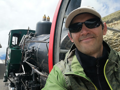
Hiking the Brienzer Rothorn – My Highest Elevation Gain Yet!
Overview
- Starting point: Brienz (600m)
- Arrival: Brienzer Rothhorn (2,348m)
- Altitude gain: 1,748m
- Duration: ~5 hours ascent, 40 min descent (by train)
- Difficulty: Hard
- Technical difficulty: Moderate (due to snowfields)
The Brienzer Rothhorn had been on my hiking list for a while. As the highest point in Canton Luzern, it’s a long and demanding route, and I never found the right moment to tackle it. But in 2024, while training for Capanna Margherita, I needed longer hikes to prepare. When the weekend forecast showed perfect weather, I knew it was time. Like always, I decided the night before—one of the perks of living close to the Alps!
I left home at 6:30 AM and, by 8:00 AM, I was parked in Brienz (600m), a charming village on the shores of Lake Brienz, opposite Interlaken, in canton Bern. The hike starts near the steam train station—yes, there’s an actual steam train that goes to the summit, but more on that later.
The trail begins on paved roads that gradually fade into the woods. The first hour and a half was straightforward, following a well-marked path through the forest. Eventually, I reached Planalp (1,350m), the train’s intermediate station, where there’s also a restaurant. If you want to shorten the hike, you can take the train up to this point and walk the rest—it’s still a decent climb from here.

The Unexpected Obstacle
As I passed the station, I saw a sign:
"Due to snow, the upper part of the trail is closed."
Bummer. I had waited a long time for this hike. I hesitated for a moment, but then a train arrived, and I rushed back to buy a ticket for the second half. However, the train conductor told me I needed to purchase it from the vending machine. I fumbled with my credit card, and just as I finished… the train left. Double bummer. The next one was in an hour.
Meanwhile, I noticed a few hikers ignoring the warning sign and continuing up. I decided to follow them. I chatted in my broken German with an older Swiss hiker, who assured me there was no real danger, so I pressed on.
Pushing Through
The path after Planalp follows a gravel road leading into a valley that bends to the right. I took a quick snack break before continuing. All along the way, I could see the steam train chugging up the mountain, trailing a plume of smoke.


After another hour, at around 1,800m, the final push began. The trail got steeper but remained manageable—until I hit the snow. The warning sign wasn’t lying. Even though it was June, large snowfields remained, making the final ascent tricky. Luckily, I wasn’t alone; seeing other hikers push forward gave me the confidence to continue.
The first two snowfields were passable with caution. But the third one… wasn’t.
By this point, I had gained almost 1,700m in elevation—a personal record—and I was exhausted. The last snowfield was steep and dangerous. But I was so close...
I made a drastic decision. The official trail zigzagged across the snowy slope multiple times, but the snow itself formed a narrow tongue. Beside it, the terrain was clear. Instead of following the path, I cut straight up, hugging the snowfield’s edge. It was brutally steep, and I had to stop frequently, but after 20-30 grueling minutes, I made it! I rejoined the trail just 50m from the restaurant at 2300m.
Reaching the Summit
From there, the final stretch was easy—a wide tourist path leading to the summit at 2,348m.
I reached the peak, caught my breath, and took in the breathtaking panorama. Below me, Lake Brienz shimmered in the sunlight, with Lake Thun visible in the distance. To the west, I could see all the way to Mount Pilatus. The view was absolutely worth the struggle.

After a while, the cold set in, so I headed back to the mountaintop restaurant. As is now my tradition after a tough hike, I treated myself to a cappuccino and cake. The contrast was surreal—after a brutal climb, I found myself surrounded by tourists in city shoes, casually taking photos.
The Descent – A Journey Back in Time
I made my way to the train station to check if I could use my unused ticket for the descent. Luckily, I could. With 30 minutes until departure, I climbed a nearby hill for some selfies, but I quickly realized my mistake. Crowds were forming, and seats were limited. I rushed back and managed to secure a spot.

The descent on the steam train was like stepping back in time. Over 40 minutes, we slowly made our way down, smoke billowing above us, while the conductor manually switched the tracks at each junction. It was a well-earned and nostalgic way to end my record-breaking hike.


Comments
Post a Comment