Hiking the Barrhorn – The Highest Marked Trail in the Alps
The Barrhorn is known as the highest officially marked hiking trail in the Alps that doesn’t require mountaineering equipment. At 3,610m, you reach the summit with nothing more than a good pair of boots (plus the usual mountain essentials, of course). The route passes by the Turtmannhütte, offering breathtaking views of glaciers and high peaks along the way.
Day 1: The Ascent to Turtmannhütte
I started the hike at the parking lot in the valley, sitting at 1,900m.
💡Important tip: bring cash! The parking is paid, and my phone had no signal, so I couldn’t use the app. Since I had neither cash nor network, I had to take my chances and leave my car as it was. I told myself I’d pay as soon as I got a signal. And guess what? I only got network at 3,500m! It took a while.
The first part of the hike follows a gravel road, a very pleasant walk up to the dam and artificial lakes—about one hour in. This section is easy and ideal for a picnic or a relaxed family outing. From here, the glacier dominates the view, majestic and imposing.
At Turtmannhütte (2,500m), the atmosphere is simple, as you’d expect from a CAS (Swiss Alpine Club) hut. Surrounding the hut, high cairns mark the landscape, and the constant hum of the glacier fills the air—its moving ice and flowing water create a surprisingly loud background noise.
Inside, I checked in and proudly flashed my brand-new CAS membership card! Interestingly, despite the hut being just past the language border, no one spoke French. Considering that St-Luc (a French-speaking village) is only 5-6 km away as the crow flies, I found that amusing. But we managed to understand each other anyway.
Dinner was classic mountain hut fare—not exactly gourmet, but it did the job. I met some interesting fellow hikers:
- A couple of Italian data scientists from Zurich
- A Polish couple working at one of our clients
- A Swiss woman hiking solo (finally, another solo hiker! Sometimes, I feel like I’m the only one who does this alone).
As is tradition: early to bed (20:30-21:00), early to rise (5:30). After breakfast, I was on my way before 7:00
Day 2: The Summit
Leaving the hut, the trail follows a flattish path along the slope toward a col. Ten minutes in, you reach the most "difficult" part of the hike—rocky and steep, with a few ropes for assistance. You might have to use your hands a bit, but there’s no real danger, as long as there’s no snow.
After the col, a long, wide valley stretches ahead, gradually climbing. The terrain shifts from grassy to rocky, and you hike through this section for about an hour. The glacier remains below to your left, while the Bishorn (4,000m+) stands proudly ahead.
Here, I passed two guys carrying their bikes on their backs. It looked brutal—I wished them luck, but for me, mountains are for hiking.
Then came the final ascent—steeper, with loose gravel that can be annoying. There are two options:
- A more direct route (left)
- A longer, more gradual path (right)
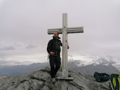
I took the direct route going up and the longer one coming down. By now, I was feeling the altitude and had to slow down, but technically, it remained easy. At 10:00, I reached the summit! Finally, I got a phone signal and was able to pay for my parking!
I didn’t stay long—the weather changed fast, and within 10 minutes, my hands were freezing. Time to head down.
For the descent, on the first 100m I followed the same route, but then I took a small alternative path on the right that descended less steeply along the ridge, offering different views. Later, it rejoined the main trail. I highly recommend doing the ascent and descent on different paths to experience the full variety of landscapes.
The Descent in the Rain
At this point, it started raining—light at first, then heavily. Good thing I got to test my Quechua shell, which worked surprisingly well—I didn’t get too wet. The descent was long but not difficult in 3h I was down.
For the last part, instead of taking the gravel road again, I followed an alternative route through the gorge and along the river on the opposite side with respect to the gravel road I did climgin up. It’s a more adventurous and scenic path.
Finally, back at the parking lot—no ticket! Lucky me! Though, honestly, getting a fine on a Sunday at the end of a remote valley would have been crazy… but hey, this is Switzerland—anything is possible.
On my way back, I ran into the two Italian data scientists. They had no car and were about to hike their way back to Zurich (?!). I gave them a lift to Turtmann station, then headed home.
Final Thoughts
The Barrhorn is a fantastic hike—challenging but doable without technical gear, offering stunning glacier views and a real sense of adventure. If you're up for a high-altitude experience without mountaineering, this is one of the best hikes in the Alps. Just remember: ✅ Bring cash for parking.


Comments
Post a Comment