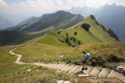
Klingenstock from Stoos
Hiking the Stoos Ridge: Fronalpstock to Klingenstock
Overview
Starting Point: Stoos village (1,300m)
End Point: Klingenstock (1,925m)
Total Elevation Gain: Approx. 900m (600m to Fronalpstock + 300m undulating ridge climb)
Distance: Approx. 10 km
Duration: 5 to 6 hours ( or just 2 if you use the chairlift)
Difficulty: Moderate – steep ascent initially, exposed ridge but safe
Best Season: Late spring to early autumn
Special Features: Europe’s steepest funicular, stunning ridge walk, panoramic views of Lake Lucerne
Reaching Stoos
This hike is set at the heart of Switzerland, above Lake Lucerne (also knows as Four Cantons Lake), in Canton Schwyz. It is known as one of the most dramatic ridge walks in Switzerland, yet remains completely safe.
The hike starts in Stoos, a car-free village accessible only via the steepest funicular in Europe. In classic Swiss marketing style, everything must be the "top" of something, and this funicular certainly lives up to the hype. The futuristic vehicle, composed of four bubble-shaped cars, climbs almost vertically through a cliff, passes a short tunnel, and suddenly emerges onto a vast, grassy plateau where the charming village of Stoos lies.
The Ridge Hike
From here, you can take a chairlift to the ridge, but we chose to hike up. The path is well-marked, crossing rolling pastures, but the climb is significant—600m of elevation gain from Stoos (1,300m) to Fronalpstock (1,900m).
The Final Descent
At 1,925m, the ridge ends at Klingenstock, slightly higher than where it began. Here, you have two options: take the chairlift down or descend on foot. True to our poverty, we opted for the latter, adding another 1h 45m to our hike. The descent is straightforward, and at the bottom of the chairlift, numerous mountain huts await with well-deserved refreshments.
One tip: there are few food stops along the ridge itself, so if you're hiking the full trail, bring a sandwich!


Comments
Post a Comment