Furstin Gina Weg
Overview
-
Location: Malbun, Liechtenstein
-
Starting altitude: ~2000 m (top of Sareis chairlift)
-
Highest point: 2359 m (Augstenberg)
-
Distance: 10 km
-
Elevation gain/loss: 520 m up, 900 m down
-
Duration: Approx. 3 hours
-
Difficulty: Moderate; longish and some steep sections on the ridge
So I made an effort to remember... and one thing I remember for sure: it was a beautiful hike.
The trail is called the Fürstin Gina Weg (Princess Gina Trail), named in memory of the princess. It starts in Malbun at 1650 meters, the little mountain village of this tiny country (although honestly, most of Liechtenstein feels like one big mountain village).
You'll find parking at the bottom of the Sareis chairlift. From there, you can ride up to the trailhead at the top station, just shy of 2000 meters. Already from the start, you'll enjoy great views and find a small hut.
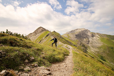
The beauty of this hike lies in the fact that it follows a panoramic ridge almost the entire way. The path is always well-marked and wide enough, making it accessible without particular difficulties.
If you wish, you could continue along the ridge to Naafkopf (2500 m), but the descent from there is much longer and more technical, turning into a bit of mountaineering. We chose instead to leave the ridge and descend toward the Liechtenstein side.
The descent over grassy slopes makes the second half of the hike very pleasant as you head down the valley all the way back to Malbun.
Overall:
-
The full loop is about 10 kilometers, with 520 meters of ascent and 900 meters of descent.
-
It takes around 3 hours to complete.
-
To make the hike longer, you can skip the chairlift and climb directly from Malbun.


Comments
Post a Comment