Augstmatthorn, top of Interlaken
-
Start: Harderbahn funicular top station (1300 m)
-
End: Augstmatthorn summit (2137 m)
-
Elevation gain: ~960 m (return including ups and down along the ridge)
-
Total time: ~6h at a brisk pace (3h10 up, 2h40 down)
-
Length : 17.5km return
-
Return: Same way or alternative descents to Lombachalp (bus) or Riggisberg (train)
-
Pro tip: Start early to avoid queues at Harderbahn, and treat yourself to a cappuccino at Harderkulm!
The hike to Augstmatthorn begins at the top station of the Harderbahn funicular. While it’s possible to start from the bottom, that would make for a veeeeeeery long day—and besides, the funicular is fun! Just note that on weekends it can get busy, with long queues. I visited on a Saturday: I didn’t have to wait for the first run at 9:10, but I waited a good 40 minutes for the return trip at 15:00.
From the top station (1300 m), a short paved path leads to Harderkulm and its viewing platform overlooking Interlaken. Just before the restaurant, a right turn points you toward Augstmatthorn. The hiking signs say it takes 3h30 to reach the summit—problematic since I had left my car in a 5-hour parking spot! But it was a good motivation to move quickly and a great training push. After all, it’s “only” 800 m of elevation gain, no?
Past a small playground, the real hike begins through the forest on a wide trail. After about 15 minutes, you reach a fork: right loops back to Harderkulm, while left continues along the Hardergrat ridge—famously (or infamously) one of Switzerland’s most dangerous ridge hikes. But don't worry, the really exposed section comes only after Augstmatthorn.
Another 15 minutes later, a sign points to a viewpoint you can visit if you’re short on time, but I pressed on. The trail became muddy and narrow in places due to rain the previous days, but I never felt it was truly dangerous—just be sure to stay on the main trail, as some side paths are quite steep.
After about an hour, you reach Roteflue. You don’t climb it (you’d need ropes for that!), but the trail skirts its base beneath an impressive cliff. From here, the forest thins, and you begin to glimpse Lake Brienz below.
From Suggiturm, Augstmatthorn is only 1 km away with just 50 m of extra elevation. I briefly considered turning back to avoid overstaying my parking time, but how could I skip the final stretch? I continued—and was well rewarded!
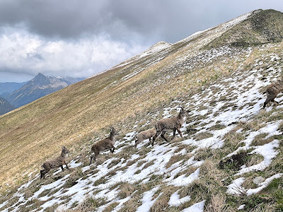
Just after Suggiturm, there’s a thrilling 50 m section of real Hardergrat: a narrow ridge with vertical cliffs on either side. It’s not particularly dangerous since it only takes 20 seconds to cross and the path is wide enough, but I can’t imagine doing that for hours! After this section, a short descent leads to broader paths again, and here came my second reward: chamois sightings!
The final 15–20 minutes to Augstmatthorn (2137 m) were easy, even with some snowfields to cross. And at the summit—third reward: a summit book to sign! The view is similar to Suggiturm, but you can also look back on the narrow ridge you just traversed, which seems more intimidating than it actually is.
The return is the same way, though you could descend to Lombachalp (bus to Interlaken) or down to Riggisberg on the lake (3 h hike + train back). I stuck to retracing my steps to enjoy my traditional high-altitude cappuccino at Harderkulm.


Comments
Post a Comment