This post is special, because it will bring the count of hikes in my blog above 100! So I think it is good to celebrate this achievement at home. So here is another forgotten hikes post, this time in Vaud, my home canton!
Le trou à l'ours, Bex
- Start point: Point-de-nant, 1250m
- Destination: Trous à l'ours, 1630m
- Highest point: Destination
- Distance: ~6.5 km loop
- Elevation gain: ~400 m
- Time: ~2h loop
- Difficulty: Easy to moderate
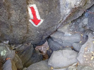
I have unfortunately lost the pictures of this one. Pity, because I remember it as a nice hike (even though I don't remember much). It starts in Pont de Nant after Plan sur Bex. It is the same place from where the via ferrata Le Lavanchy starts. The path is well marked. It starts on a large road starting after the Auberge Communcale. It goeas through the forest for about 1h then it turn back and starts to climb the side of the mountain. Here you'll find the highlight of the hike: the "hole of the bear" (trou à l'ours). This is a small natural rock gallery that you need to climb into. No worries it is narrow but not long and not difficult. When you come out you find yourself on a rock flat that gives you a good view in the valley. After this you go back downhill through the forest to the starting point.
Col du Pillon, Les Diablerets
- Start point: Col du Pillon, 1546m
- Destination: Lac Retaud, 1730m
- Highest point: Destination
- Distance: 5 km loop
- Elevation gain: ~170 m
- Time: ~2h loop
- Difficulty: Easy
This is a hike that can be done in all seasons as it is marked as a snowshoe hike in winter and we did it that way. To get there you park at Col du Pillon, 1546m, the base of Glacier 3000. Then go slightly back towards Les Diablerets where the trail starts on the right. The first part is large but then it goes right into the forest and becomes smaller. The hike brings you to chalet du Rard, 1680m, which happens to be the last building of canton Vaud as the boader to Bern is just next the chalet. After the path turns slowly left to come back to Lac Retaud, 1685m, where you'll also find a hut open on all seasons. From there you can follow the large groomed road that will bring you down to Col du Pillon.
Pra Cornet, Les Mosses
- Start point: Les Mosses, 1450m
- Destination: Ridge behind Pra Cornet, 1730m
- Highest point: Destination
- Distance: 12.5 km loop
- Elevation gain: ~430 m
- Time: ~4h
- Difficulty: Easy, just a bit long


Lac d'Hongrin, La Lécherette
- Start point: La Lécherette, 1400m
- Destination: Barrage d'Hongrin, 1255m
- Highest point: Sonlomont, 1530m
- Distance: ~16 km loop
- Elevation gain: ~530 m
- Time: ~4-5h loop
- Difficulty: Easy, just a bit long
Download GPS file
This is a quiet and relaxing hike. You start in La Lécherette, 1400m, where there is ample space for parking. From there you take the road towards Lac d'Hongrin. You can choose several paths. We decided take the one along the lake shore first and the upper one on the hills above on the way back. The lower one is a wide gravel road that continues almost flat to the dam (lac d'Hongrin is an artificial one). We crossed the dam just to look from a above and then we came back. After retracing the road for a couple hundred meters we took the path branching towards the hill. This is a narrower trail but still without difficulties that retraces the same way back just a bit more uphill passing by Sonlomont, 1530m. Overall it is a fairly long hike, 16km but with only 530m elevation and very green and hilly landscapes.
Dent de Jaman, Les Avants
- Start point: Col de Jaman, 1512m
- Destination: Dent de Jaman, 1875m
- Highest point: Destination
- Distance: ~5 km loop
- Elevation gain: ~400 m
- Time: 2h-2h30 loop
- Difficulty: Moderate to hard
To get to Dent de Jamain you start from the homonimous Col, 1512m, which in turn you reach with a very narrow road so careful!. At the Col you'll also find a hut where you can stop on the way back.
From the Col, that is just below the Dent, you start on the trail on the right that climbs quite steeply the foot of the Dent and then turns around it and finally climbs on it from the back. The last 100m are a bit exposed and, although not marked as a high mountain trail, it was difficult enough to stop some friends who came with us. The steep part only lasts 15 Min and then you get to the summit cross at 1875m. The way back is via the same path or, as an alternative, you can go to the Buvette de Jaman, 1742m, not far from the foot of the Dent on the opposite side with respect to the Col. The hut is just in front of the Jaman train station! Strange place to find a train! If you want to can take it visit Rocher de Naye. If instead you want to go back, from the buvette you can also go via a smoother path down the valley in between Dent de Jaman and Rocher de Naye that will take you to Col de Jaman in a larger tour in about 1h and no difficulties.


Comments
Post a Comment