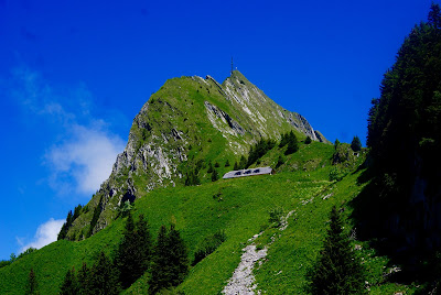
Rocher de Naye
🥾 Overview
Starting Point: Haut de Caux (1,180 m)
Summit Altitude: 2,045 m
Elevation Gain: ~865 m
Distance: ~12 km
Time (round trip): 4-5 hours (depending on route)
Difficulty: Moderate (some steep paths and snow risk in early season)
Best Season: Mid-June to October
Highlights:
Cogwheel train station at the summit
Marmots & panoramic views of Lake Geneva
Alpine botanical garden with a Buddhist stupa
Optional K5 via ferrata for thrill-seekers
Rocher de Naye can be considered a classic – even if I don’t hike it every year. It’s a renowned destination near where I live, known for its iconic cogwheel mountain train – perhaps the only one in French-speaking Switzerland that rivals those in Central Switzerland.
While there are many ways to reach the summit, I usually start from Haut de Caux (1180 m), where you’ll find a small parking area right next to the train station of the same name.
While there are many ways to reach the summit, I usually start from Haut de Caux (1180 m), where you’ll find a small parking area right next to the train station of the same name.
Route Options from Haut de Caux
From this starting point, there are three main variants to reach the summit:
Directly next to the train line – Steep and scenic, but less common.
Cutting through the pastures – My usual route: more direct, quite steep but manageable.
Following the main road – A gentler, longer loop (adds ~2 km), great for early season or snow conditions.
I typically choose the middle path: I start on the wide road, which is almost flat for the first 15 minutes, then take a small trail on the left that climbs quickly through forest and into alpine pastures. The trail is steep but safe, unless there’s lingering snow.
⚠️ Warning: Near the top of the pastures, you must cross a steep couloir. Snow often persists here until early June. If snow-covered, this passage becomes treacherous and should be avoided. I once had to turn back. So I recommend this route only from mid-June onward. Before that, stick to the main road.
The first variant (next to the train) also ends up at this couloir but approaches it more gently, while the main road completely avoids it – heading around the ridge and climbing on a sunnier south facing slope, which becomes snow-free earlier.
Stop at Sautodoz and Final Ascent
Just above the couloir, all paths merge at Sautodoz (1810 m), a peaceful alpage where you can rest and enjoy beautiful views.
From here, the final stretch climbs a rocky slope on a wide path. As you turn onto the ridge, Rocher de Naye hut appears, perched at 1980 m right next to the train station.
Summit and Surroundings
There’s more than just hiking:
🐹 Marmots roam the meadows below the hut.
🌸 A charming alpine botanical garden lies just 10 minutes to the right, with a Buddhist stupa at its entrance.
⛰️ The summit (2,045 m) is only 10 minutes farther. From there, enjoy a stunning panorama of Lake Geneva and dramatic ridge views.
A few more minutes along the cliff, you’ll find the upper end of the K5 via ferrata – a serious climb up the vertical face of the mountain. If you’re looking for a thrill and have experience, it’s a bold way to the top.
🚞 Way Down
To descend, you can take any of the three ascent routes – except the steep pasture route, which can be hard on the knees. Or simply hop on the mountain train, which takes you back to Haut de Caux in just over 20 minutes.
🚞 Way Down
To descend, you can take any of the three ascent routes – except the steep pasture route, which can be hard on the knees. Or simply hop on the mountain train, which takes you back to Haut de Caux in just over 20 minutes.


Comments
Post a Comment