Tour du Grand Chavelard

Overview
-
Start point: Jorasse (1940m), via cable car from Ovronnaz
-
Highest point: Col du Fenestral, 2452m
-
Total elevation gain: ~800m
-
Duration: ~5 hours loop (with breaks)
-
Difficulty: Not technically difficult but long

The Hike
For once, I had planned to stay home, but my dad was visiting and eager for a hike. So we headed out for the Tour du Grand Chavalard, a loop I had long wanted to explore.
There are several starting points for the tour. We chose Ovronnaz and quickly made our way up to the Jorasse restaurant (1940m) using the Magic Pass cable car. From there, the trail options are clearly marked. The one for Grand Chavalard is on the left and almost immediately turns left again behind the restaurant.


The Choice: Clockwise or Counterclockwise?


After about 20 minutes, we reached Petit Pré, a small alpine meadow where the real loop begins. At this point, you have to choose:
-
Right for a clockwise route with more ascent early on
-
Left for counterclockwise, saving the steeper climb for the end
We opted to go right, aiming to arrive at Cabane de Fenestral around lunchtime. Going the other way would have brought us there too early.


Luis d’Aout to L’Erié

The first stretch follows a wide gravel road with some scenic shortcuts. Soon, we passed the Luis d’Aout hut without stopping and continued through forested areas and narrow paths with a steep drop to one side — always safe, though a bit vertiginous in parts.

The trail then becomes rockier as it skirts a cliff, eventually reaching the lowest point of the hike at 1840m. A gentle ascent brought us to L’Erié (1880m), a secondary trailhead accessible by a gravel road.

Climbing Toward the Lakes
From L’Erié, the trail widens and offers impressive views of the valley below and the Grand Combin ahead. The climb becomes steadier. After passing through a short wooded section, we emerged into the open, hiking beneath cliffs under the hot sun. Thankfully, we found a couple of small streams to cool off.


Rounding the ridge, the first Lac de Fully came into view, and after 10 minutes, the trail joined a wider road that heads toward Sorniot hut (2060m). Just before the hut, we spotted a faint, unmarked trail on the right — our app recommended it, so we took it.

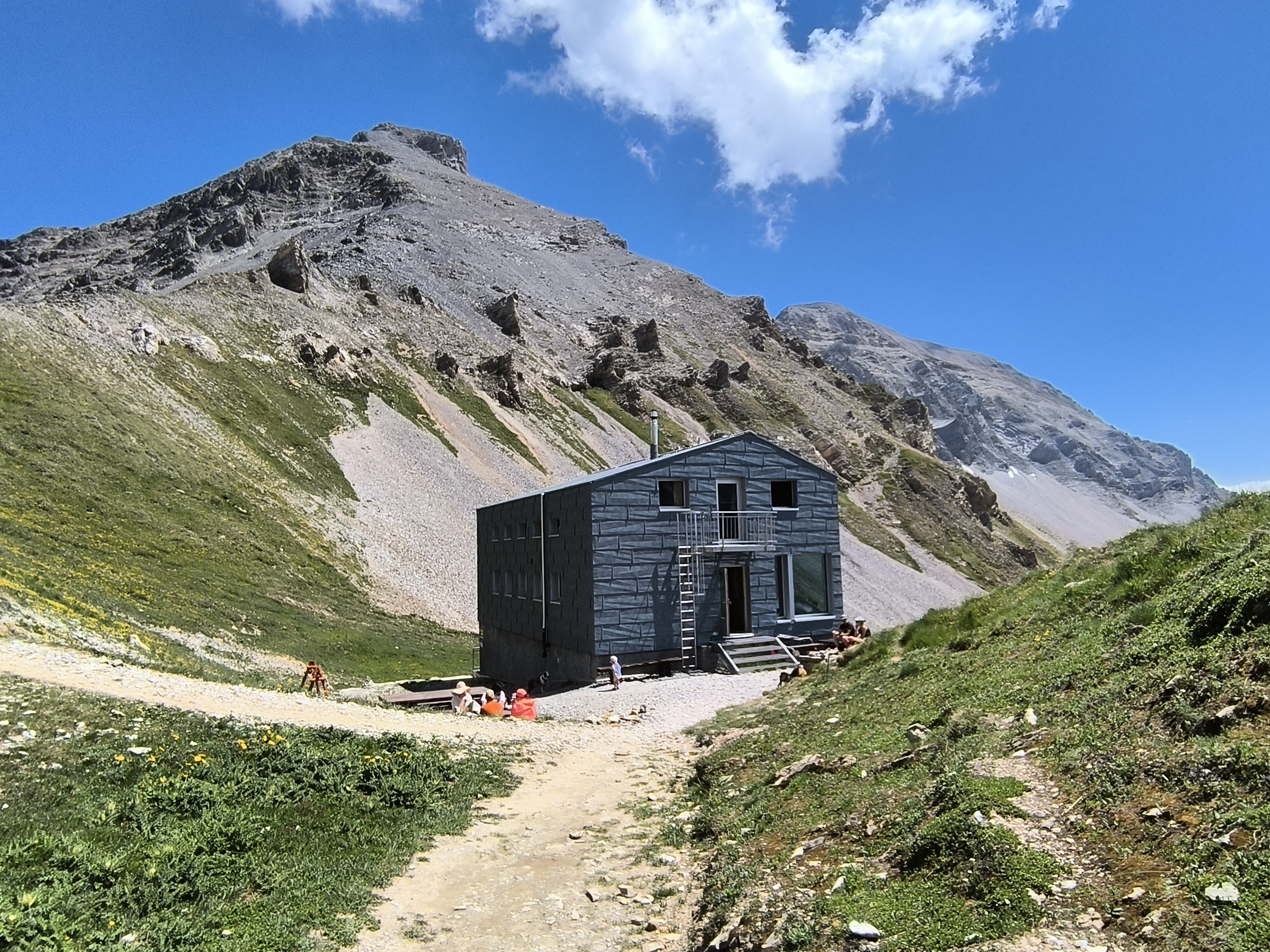
The Final Ascent to Cabane de Fenestral

This shortcut is a steep grassy slope that quickly turns into a mini scramble. For the first while, you can’t see the lake or the hut. Eventually, the second Lac de Fully appears, and soon after, the Cabane de Fenestral (2434m) comes into view — only to disappear again behind a hill before finally revealing itself.


The Col and Descent
A short, 2-minute walk brought us to Col du Fenestral (2452m), the highest point of the hike. From here, trails continue to Les Dents de Morcles, but this time we headed downhill.


The descent is steep for about 30 minutes, then levels off across an open alpine plain before gradually descending back to Petit Pré. Just before the meadow, there’s a small shortcut on the left that rejoins the original trail. From there, it’s a 15-minute walk back to Jorasse.


Comments
Post a Comment